Rinjani is not a casual day hike. It's three days of volcanic terrain, one pre-dawn summit push at altitude, and a crater lake that makes the whole thing worth the legs. The trek has been getting more regulated — 2026 brought trail closures, mandatory insurance, and a Geopark management push that changes the logistics from even a year ago. This is what the route actually looks like now.
Mount Rinjani Trekking
lombok · 3D
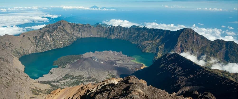
Summit Indonesia's second-highest volcano (3,726m) with overnight camps at the crater rim and lakeside hot springs. Segara Anak crater lake and Gunung Baru mini volcano inside make this one of Southeast Asia's greatest treks.
from
$129 USD
What changed in 2026
Starting January 2026, six of Rinjani's secondary trails were closed to reduce environmental damage. The two main routes — Sembalun gate and Senaru gate — remain open. Most trekkers now do the Sembalun → Senaru traverse (or reverse), which covers the summit, crater lake, and hot springs in one through-hike.
Mandatory travel insurance was introduced in 2026 at IDR 290,000 per person, purchased at the registration centre or pre-booked with your operator. This covers basic evacuation — it does not replace personal travel insurance, which you should have anyway.
The national park rolled out a digital registration system at Sembalun gate — ticket counters with queue barriers and a self-service kiosk. Present your booking confirmation and ID at the Rinjani Information Centre before the trek begins. The centre sits at the "Welcome to Geopark Rinjani" gate, right on the main road — you can't miss the yellow arch.
The route: 3D2N Sembalun → Summit → Lake → Senaru
This is the most popular configuration and the one most operators sell. It covers summit and lake in one through-hike, ending at a different gate than where you started.
Day 1 — Sembalun Lawang to Sembalun Crater Rim (2,639m)
Registration at the Rinjani Information Centre in Sembalun Lawang (1,156m) between 07:00–08:00. Porters assemble, bags weighed, permits checked.
The first stretch is open savanna grassland — exposed, no shade, gradually steepening. Post 1 (1,300m) offers the last clear view back over the Sembalun valley. Post 2 (1,500m) is the lunch stop — porters cook a full hot meal here. Post 3 (1,800m) is where the vegetation thins and the incline gets serious.
Arrive at the Sembalun Crater Rim (2,639m) around 17:00. The campsite sits on the rim with direct views down to Segara Anak lake and up to the summit cone. Sunset from here is the first reward. Dinner cooked by porters. Sleep in tents — it gets cold, bring layers.
Distance: ~8.5 km | Elevation gain: ~1,500m | Time: 7–9 hours
Day 2 — Summit push (3,726m) + descent to Segara Anak Lake (2,000m)
Wake at 02:00. Light breakfast. Headlamps on by 02:30.
The summit push is 3 hours of loose volcanic scree — two steps forward, one sliding back. No technical climbing, but the altitude and surface make it genuinely hard. There's no shortcut and no alternative path. The last 200m vertical is the steepest.
Summit (3,726m) around 05:30–06:00. On a clear morning: 360° view — Gili Islands to the northwest, Gunung Agung across the strait, Gunung Tambora to the east, and Segara Anak lake 600m directly below. Sunrise hits the crater wall in layers. This is why you came.
Descend back to crater rim by 08:00 for full breakfast. Then a steep descent into the caldera — ~600m drop on switchbacks — to Segara Anak Lake (2,000m). Arrive lakeside around 12:00–13:00 for lunch.
Afternoon options: swim in the lake (cold but reviving), or walk 10 minutes along the shore to Aiq Kalak hot springs — natural volcanic pools right at the water's edge. The hot springs after a summit day is the second reward.
Ascend 3 inner caldera hills toward the Senaru Crater Rim (2,641m) in late afternoon. Camp, dinner, overnight.
Distance: ~11 km | Elevation: +1,087m (summit push) then −1,726m + various caldera undulations | Time: 12–14 hours total
Day 3 — Senaru Crater Rim to Senaru Village (601m)
Breakfast at 08:00. Pack camp by 08:30.
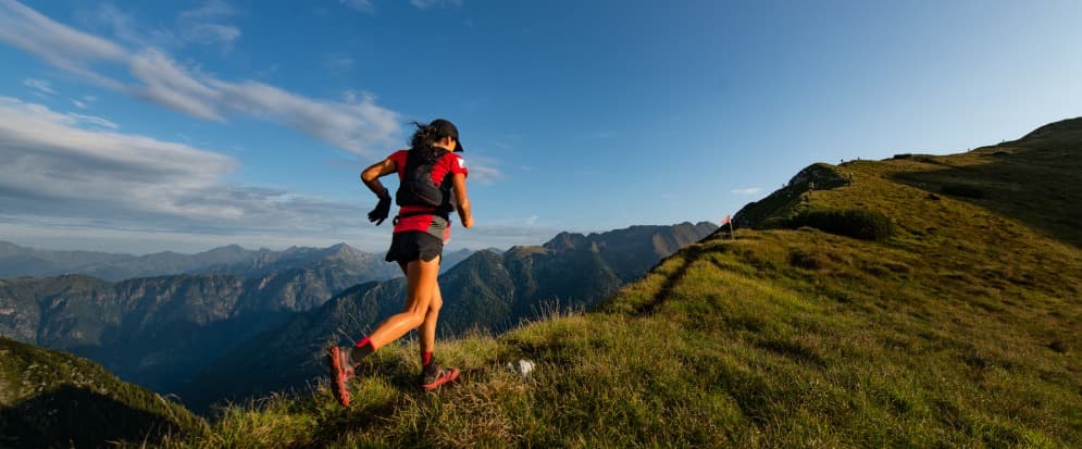
The Senaru descent is lush — dense tropical rainforest, a complete contrast from the barren scree above. Tree roots as steps, canopy overhead, occasional monkey sightings. The trail drops roughly 2,000m over ~8 km — it's steep and your knees will know it.
Arrive at Senaru Rinjani Trekking Centre (601m) around 13:00–14:00. Certificate issued. Transfer to Mataram, Senggigi, or Lombok airport.
Distance: ~8 km | Elevation loss: ~2,040m | Time: 4–5 hours
Costs
Mount Rinjani Trekking
lombok · 3D
Summit Indonesia's second-highest volcano (3,726m) with overnight camps at the crater rim and lakeside hot springs. Segara Anak crater lake and Gunung Baru mini volcano inside make this one of Southeast Asia's greatest treks.
from
$129 USD
| Item | Budget | Standard | Comfort |
|---|---|---|---|
| Operator package (3D2N) | IDR 2,000,000 | IDR 3,000,000 | IDR 5,000,000 |
| Insurance (mandatory 2026) | IDR 290,000 | IDR 290,000 | IDR 290,000 |
| Transfer airport ↔ Sembalun | Included | Included | Included |
| Extra porter | — | — | ~IDR 500,000 |
| Tips (guide, per day) | IDR 150,000 | IDR 200,000 | IDR 300,000 |
| Tips (porter, per day) | IDR 75,000 | IDR 100,000 | IDR 150,000 |
| Total per person | ~IDR 2,700,000 | ~IDR 4,200,000 | ~IDR 6,800,000 |
What to bring
Non-negotiable:
- Hiking boots (broken in — new boots on Rinjani is a mistake)
- Rain jacket (weather shifts fast above 2,500m)
- Headlamp + spare batteries (summit push starts at 02:30 in the dark)
- 2L water capacity (refill from porters at camps)
- Warm layers for summit night (0–5°C at the rim, colder on summit)
- Sunscreen + hat (savanna exposure Day 1)
Strongly recommended:
- Trekking poles (knees on the Senaru descent will thank you)
- Dry bags for electronics (condensation and rain)
- Altitude sickness medication if sensitive (3,726m — not extreme, but enough)
- Toilet paper + hand sanitizer (toilet tents are basic)
- Cash for tips (no ATM on the mountain)
Leave behind:
- Heavy camera gear (phone cameras are fine, less weight = less suffering)
- Cotton clothing (stays wet, gets cold)
- Flip flops (seen it, don't do it)
Getting there
balilombok
jakartalombok
Airport to Sembalun Lawang: 2.5–3 hours by car. Most operators include this transfer — they pick you up the afternoon before Day 1 and drop you at a guesthouse in Sembalun. Confirm with your operator; some budget packages start from Mataram or Senggigi instead.
When to go
April–November is trekking season. May–September is the sweet spot — driest, clearest summit views, calmest weather. July–August is peak season (book 2–4 weeks ahead).
December–March the park technically remains open, but trails are slippery, visibility drops, and some operators won't run. Summit success rate drops significantly in wet season.
The summit push happens before dawn regardless of season. Wind chill at 3,700m with no sun is real — even in dry season, the rim temperature sits around 0–5°C.
Frequently Asked Questions
How fit do I need to be? You need to be able to walk 8–11 km per day with 1,000–1,500m elevation gain carrying a daypack. The summit push is the hardest — 3 hours of steep scree at altitude, in the dark. Train with hill walks or stair climbing for 4–6 weeks before.
Can I do Rinjani without a guide? No. Guides are mandatory — you cannot enter the national park without a registered trekking operator. Enforced at the gate.
Is altitude sickness a concern? The summit is 3,726m — high enough for headaches and nausea during the pre-dawn push. Not Kilimanjaro-altitude, but don't dismiss it. Hydrate, ascend steadily, descend if symptoms worsen.
What about the 2026 trail closures? Six secondary trails closed January 2026. The two main routes (Sembalun and Senaru gates) remain fully open. The summit + lake traverse is unaffected.
Is there phone signal? Telkomsel at Sembalun Lawang and intermittently at crater rim. Nothing at the lake or on the Senaru descent. Don't rely on your phone.
What we'd recommend
Book the 3D2N Sembalun → Summit → Lake → Senaru route. It's the complete Rinjani — summit sunrise, crater lake, hot springs — without rushing. The 2D1N crater-rim-only option saves a day but skips the lake, which is half the point.
Book with a standard-tier operator (IDR 3M–3.5M range). The difference between budget and standard is better food, newer gear, and guides who speak enough English to tell you what you're looking at. Premium (IDR 5M+) adds thicker mattresses and private toilet tents — nice, not necessary.
Mount Rinjani Trekking
lombok · 3D
Summit Indonesia's second-highest volcano (3,726m) with overnight camps at the crater rim and lakeside hot springs. Segara Anak crater lake and Gunung Baru mini volcano inside make this one of Southeast Asia's greatest treks.
from
$129 USD
Updated May 2026 from Sembalun Lawang. Sources: Rinjani National Park registration, operator pricing (Rinjani Trek Adventure, JayaTrekker, Green Rinjani), YouTube trekker reviews Jan–May 2026.