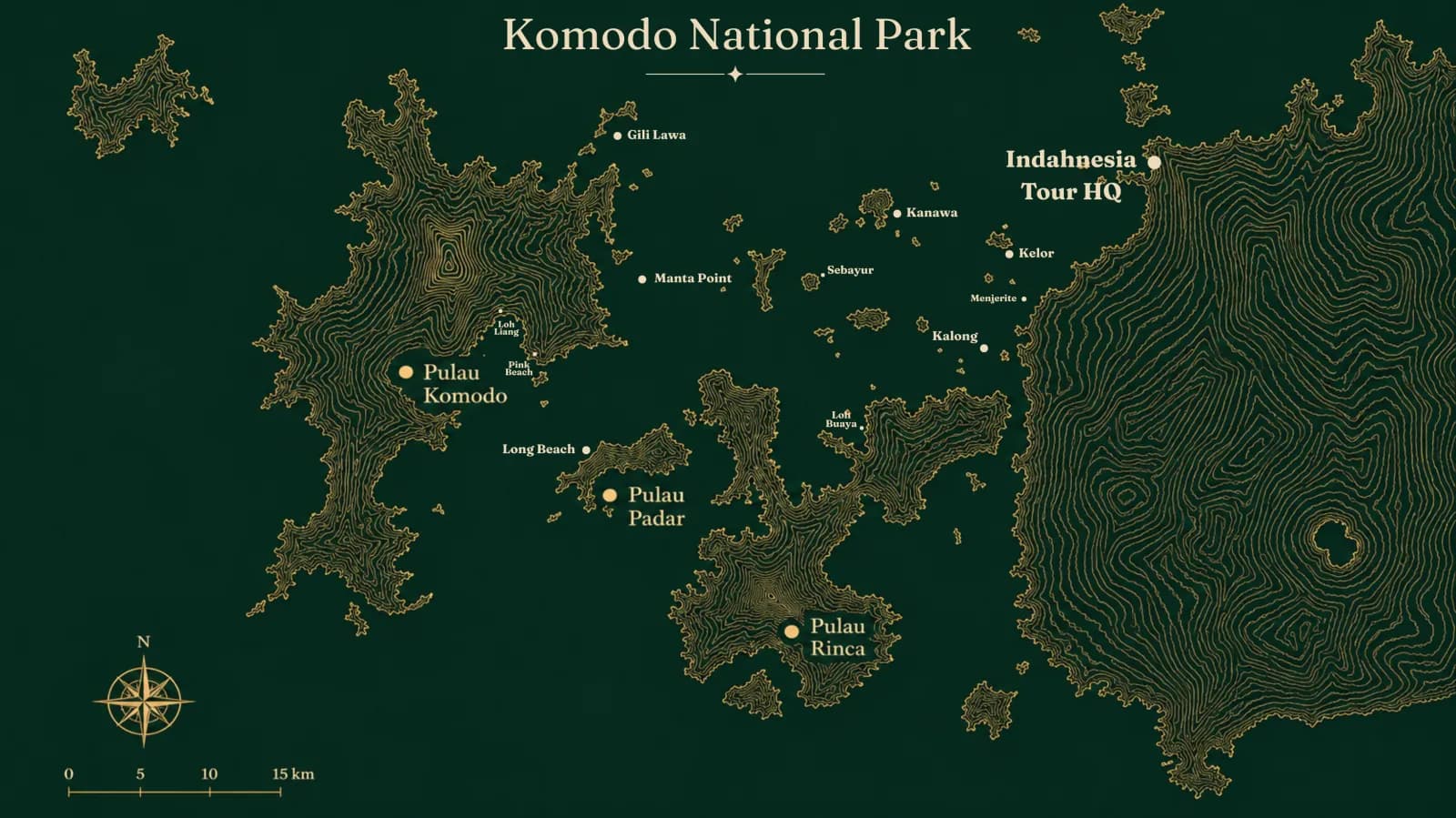
Komodo Island lies in the province of East Nusa Tenggara (Nusa Tenggara Timur, or NTT), Indonesia, in the regency of West Manggarai. It sits in the strait between Sumbawa and Flores, and the island is part of the wider Komodo National Park. On a map you'll find it at roughly 8°30′ South and 119°30′ East, within the chain of islands often called the Lesser Sunda Islands. So before we get into the map and the route in detail, the short answer is simple: the island is off the western tip of Flores, still inside East Nusa Tenggara province.
What province is Komodo Island in?
Komodo Island is in East Nusa Tenggara (NTT), not West Nusa Tenggara. The two are easy to confuse because the island sits so close to Sumbawa, which belongs to neighbouring West Nusa Tenggara (NTB). Administratively, though, Komodo Island falls under West Manggarai Regency, and more precisely within the Komodo sub-district (kecamatan). The regency's capital is Labuan Bajo, a small town on the west coast of Flores that doubles as the main gateway to the island.
West Manggarai Regency isn't just the western part of mainland Flores; it also takes in many smaller islands nearby, among them Komodo, Rinca, Seraya, Bidadari, and Longos. Komodo is the most famous of them all, chiefly because it's home to the Komodo dragon, the largest living lizard on Earth.
Komodo Island's location on the map of Indonesia
If you open a map of Indonesia and follow the southern chain of islands, Komodo Island sits right in the gap between Sumbawa to the west and Flores to the east. The narrow stretch of water separating the area from Sumbawa is the Sape Strait. Because of that in-between position, the island is often described as a meeting point of two provinces, even though its territory stays firmly on the East Nusa Tenggara side.
Geographically, the area is remarkable for more than just the dragons. Komodo Island lies within a biogeographical zone called Wallacea, a transition belt between the Asian (Sunda) and Australian wildlife realms. That dividing line is what gives the flora and fauna around Komodo a character distinct from the larger islands of western Indonesia. So when you stand on Komodo Island, you're actually in one of the most biologically unusual regions in the world.
Komodo Island at a glance
- Province: East Nusa Tenggara (NTT)
- Regency: West Manggarai
- Sub-district: Komodo
- Coordinates: approximately 8°30′ S, 119°30′ E
- Island area: roughly 339 km² (33,937 hectares)
- Location: in the Sape Strait, between Sumbawa and Flores
- Part of: Komodo National Park (a UNESCO World Heritage Site since 1991)
- Gateway: Labuan Bajo, on the west coast of Flores
The size and shape of Komodo Island
Komodo Island covers about 339 square kilometres, or roughly 33,937 hectares in the figures used by the local government. Its shape isn't a neat circle but rather deeply indented, with many bays and headlands, which gives it a long, winding coastline. The terrain is dominated by dry hills and savanna grassland that turns golden in the dry season, broken up by patches of forest in the more sheltered, humid valleys. That dry, hilly look is what sets Komodo apart from the lush, green tropical island most people picture.
It's worth separating two figures that often get mixed up: the area of Komodo Island itself (about 339 km²) is not the same as the area of Komodo National Park. The national park is far larger because it covers many islands and a stretch of sea, not just one island.
Komodo Island and Komodo National Park
Komodo National Park is the conservation area that protects Komodo Island along with the islands around it. Its total area is about 1,733 square kilometres, and tellingly, most of that is sea rather than land. Only around 603 square kilometres is land; the rest is protected marine water, valued for its coral reefs and rich sea life.
The park is made up of three larger islands — Komodo, Rinca, and Padar — plus around 26 smaller ones. It was officially established in 1980, and eleven years later, in 1991, it was named a UNESCO World Heritage Site. That status reflects more than the dragons alone: Komodo National Park is one of the most biodiverse places on Earth, on land and underwater.
Komodo Island, Labuan Bajo, and Komodo National Park: the difference
These three names are often treated as one, but they're distinct. Labuan Bajo is a town on the west coast of Flores, where the airport and harbour are; this is the starting point for almost every trip. Komodo Island is one of the islands inside the national park, and to reach it you take a boat from Labuan Bajo. Komodo National Park is the entire conservation area, taking in many islands including Komodo, Rinca, and Padar.
So if someone asks whether Labuan Bajo and Komodo Island are the same, the answer is no. Labuan Bajo is on Flores, while Komodo Island is a separate island reached by boat. Getting this distinction right matters, because it shapes how you picture the distances and travel times when planning a trip.
How to get to Komodo Island
To reach Komodo Island, you almost always start from Labuan Bajo. From major cities like Jakarta, Bali, or Surabaya, you can fly into Komodo Airport (code LBJ), which is in Labuan Bajo on Flores — not on Komodo Island itself. Keep in mind that Komodo Island has no airport, so the only way to reach it is by sea.
From the harbour in Labuan Bajo, the island is about 49 kilometres away. Travel time depends on the boat: a speedboat usually takes around 1 hour, while a slower wooden boat or phinisi can take 3 to 4 hours, depending on the route and sea conditions. Many visitors join a trip that also calls at popular spots like Padar Island, Pink Beach, and snorkelling sites, so Komodo Island becomes one stop on a longer route rather than a single destination.
komodo island
- Area (island)
- 291 km²sumber
- Travel Time (dari lbj speedboat)
- ~1–1,5 jam (speedboat)
- Transport (akses)
- kapal-only dari LBJ
Updated June 2026
pulau-komodo
- Travel Time (kapal kayu/phinisi (Labuan Bajo–Pulau Komodo))
- 3–4 jamsumber
- Travel Time (kapal cepat (Labuan Bajo–Pulau Komodo))
- 1 jam
Updated June 2026
Once you're on the island, any trek to see the dragons must be guided by a ranger (a park warden who understands the animals' behaviour). You're not allowed to explore on your own, because the Komodo dragon is a wild predator that remains dangerous even when it looks calm.
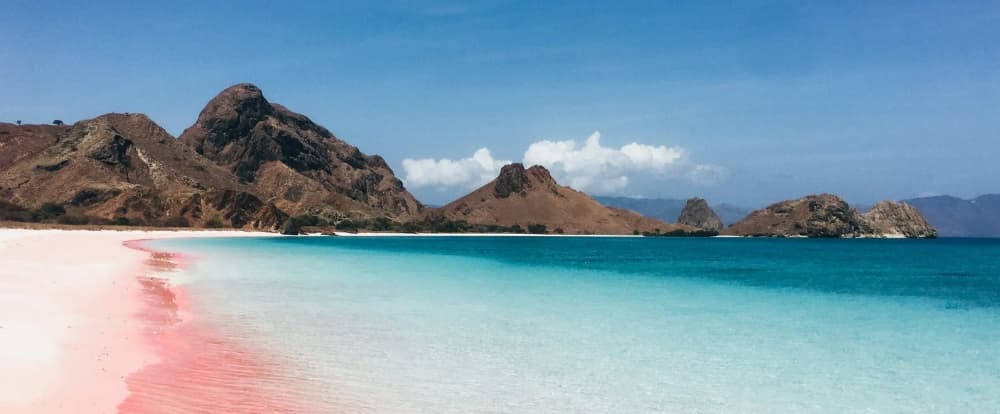
Komodo Day Trip: Padar, Pink Beach, Komodo & Manta Point
komodo · 1D
The essential Komodo day trip hitting all four highlights: Padar Island sunrise viewpoint, Pink Beach snorkeling, Komodo dragon trekking, and manta ray spotting at Manta Point. Early start from Labuan Bajo, back by sunset.
from
$145 USD
To plan the wider trip — which islands to visit, the best season, and your boat options — start with our Komodo destination guide. And if you want to know more about the animal that made this island famous, read our piece on the Komodo dragon.
FAQ
What province is Komodo Island in?
Komodo Island is in East Nusa Tenggara (NTT), within West Manggarai Regency, in the Komodo sub-district. It's often confused with West Nusa Tenggara because it lies close to Sumbawa, but administratively it belongs to East Nusa Tenggara.
Where is Komodo Island on the map?
It sits between Sumbawa (to the west) and Flores (to the east), separated from Sumbawa by the Sape Strait. Its coordinates are roughly 8°30′ South and 119°30′ East, in the Lesser Sunda Islands.
How big is Komodo Island?
Komodo Island covers about 339 square kilometres (33,937 hectares). That's different from Komodo National Park as a whole, which spans around 1,733 square kilometres because it includes many islands and a large marine area.
Are Komodo Island and Labuan Bajo the same?
No. Labuan Bajo is a town on the west coast of Flores where the airport and harbour are, while Komodo Island is a separate island inside Komodo National Park, reached by boat from Labuan Bajo.
How far is Komodo Island from Labuan Bajo?
About 49 kilometres. By speedboat the journey takes roughly 1 hour, while a wooden boat or phinisi can take 3 to 4 hours depending on the route and sea conditions.
How do you get to Komodo Island?
First fly into Komodo Airport (LBJ) in Labuan Bajo on Flores, then continue by boat from the Labuan Bajo harbour. Komodo Island has no airport, so the only access is by sea, and treks on the island must be accompanied by a ranger.